ED 262 Research, Reference & Resource Skills
2.1K views | +0 today
Follow
ED 262 Research, Reference & Resource Skills
View related curated articles on Flipboard / Research & Resource Skills at http://flip.it/mWcVKd  
Curated by Dennis Swender
Your new post is loading...
Rescooped by Dennis Swender from visual data
Scoop.it!

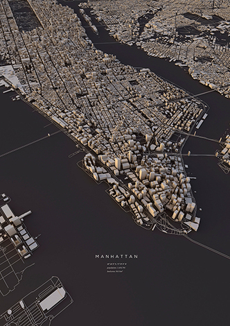
City Layouts Created with OpenStreetMap Data

City Layouts Created with OpenStreetMap Data | ED 262 Research, Reference & Resource Skills | Scoop.it

Topography, architecture and traffic routes give every city a unique structure.
'These conditions create the typical and individual inner structure of a city. I didn’t only want to show these structures in the conventional way from above, but also including the exact three-dimensionality of topography and buildings – a real world visualisation.
The OpenStreetMap data enabled me to visualize the satellite-based information using DEM Earth in Cinema 4D. The results are some extraordinary views of large capitals and small towns.'


Via Lauren Moss
No comment yet.
Rescooped by Dennis Swender from visual data
Scoop.it!

It's Never Been This Easy to Find a Great Topographical Map

It's Never Been This Easy to Find a Great Topographical Map | ED 262 Research, Reference & Resource Skills | Scoop.it
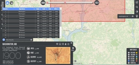
The USGS is on a open-access roll with topoView, an advanced new map-finding tool.

The cartography arm of the U.S. Geological Survey has been on an open-access roll. First they send their constantly updating stream of satellite imagery to what's basically a public dropbox, so that anyone can use Landsat-8 photographs for free. And now they're introducing topoView, an online archival tool that makes truly accessible the agency's 178,000 topographical maps, dating from 1880 (shortly after the USGS started mapping the country) to 2010.


Via Lauren Moss
Marco Favero's curator insight, May 8, 2015 6:34 AM

aggiungi la tua intuizione ...